
Precision Aerial Data Capture. NDAA-Compliant Platforms.
X0re Aerial delivers centimeter-accurate photogrammetry and inspection data using European-engineered unmanned systems — secure, certified, and cleared for critical infrastructure nationwide.
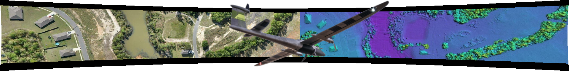
Trinity Pro Platform. German Engineering.
Zero Compromise.
X0re Aerial operates the Quantum Systems Trinity Pro, a fixed-wing VTOL unmanned aircraft system manufactured in Germany and fully compliant with U.S. National Defense Authorization Act (NDAA) Section 848 restrictions on foreign drone technology.
Platform Specifications:
Endurance: 90+ minutes flight time
Coverage: 500+ acres per sortie
GSD: 2.5 centimeter ground sample distance at operational altitude
Compliance: NDAA-compliant, cleared for federal and critical infrastructure contracts

Unlike platforms subject to import restrictions and data security concerns, our equipment offers high performance results without compromising your security protocols or regulatory standing.
Precision Data Capture for Infrastructure, Energy, and Real Estate Development.
Pre-Construction Topography
High-resolution orthomosaics, digital surface models, and contour maps for site planning, cut-fill calculations, and civil engineering.
As-Built Documentation
Georeferenced final deliverables for warranty records, interconnection documentation, and investor reporting.
Linear Infrastructure Inspection
Transmission corridors, pipeline rights-of-way, and transportation infrastructure — 90-minute endurance enables longer distance flight coverage for data collection.
Construction Progress Monitoring
Date-stamped and Geolocated visual records for milestone verification, dispute resolution, and project documentation.
Agricultural Support
Stand count verification, crop scouting, emergence mapping, and plot-level documentation for breeding trials and research programs.
GREEN UAS - CLEARED PLATFORM
Security-Cleared. Supply-Chain Verified.
X0re Aerial maintains fully compliant operations for clients with stringent security requirements:
NDAA Section 848Compliant— No prohibited components or foreign telemetry requirements
State Law Eligible— Cleared for state and municipal government contracts
Critical Infrastructure Approved— Authorized for utility, defense, and energy sector work
Data Sovereignty— All processing and storage under US entity control, no foreign cloud dependencies
Available for: Federal contracts, state and municipal projects, utility-scale solar and wind, energy transmission and distribution operators, defense-adjacent construction, and security-sensitive developments.

Construction Management Roots. Aerial Innovation.

X0re Aerial is the unmanned systems division of X0re LLC, a construction management consultancy serving utility-scale solar EPCs, infrastructure developers, and energy sector clients since 2017.
We combine field-proven construction expertise with high-grade aerial data capture — delivering actionable intelligence, not just pretty pictures.
Operating Authority: FAA Part 107 Remote Pilot Certification
Insurance: Commercial liability coverage (verification available upon request)
Service Area: Nationwide deployment capability